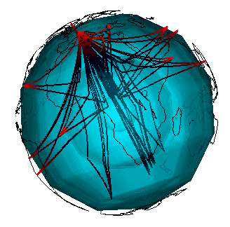
The application is a 3D mesh generator aiming at building a realistic Earth model from seismic tomography. Essential data for this model are seismic waves travel times extracted from catalogs. The catalogs are populated with data acquired with stations dispatched all around the world. The quality of the tomographic solution mainly relies on the seismic rays that link the seisms hypocenter to the receiving stations and of their geometry. Given the non-uniform geographic distribution of the stations, some regions in the Earth interior are well "illuminated" whereas some other carry poor information.
The objective is to build a non-uniform mesh so as to distribute in an homogeneous manner the available information in the mesh. The computing time as well as the RAM required to obtain a fine resolution are huge: about 5.10^6 rays should be traced in a mesh having about 10^7 cells. From the initial computed ray paths in the mesh, we proceed to a mesh refinement: the cell size grows or shrinks depending on the wealth of information contained in the cell.
The numerical resolution itself can then take place on this refined mesh. This consists of the resolution of an inverse problem.
 |
| Figure : Seismic rays that have reached Strasbourg in a one month period |